 GPRviewer
Home › Dati georadar gratuiti
Dati georadar gratuiti
Per imparare a leggere un radargramma, provare un’elaborazione o confrontare antenne, niente vale quanto le misure reali. GPRbase, la banca dati aperta di MDS, pubblica rilievi georadar reali, documentati e gratuiti, che si aprono direttamente in GPRviewer.
Apri GPRviewer gratuitamenteAccount gratuito, nessuna installazione, direttamente nel browser.
Ogni dataset è descritto su GPRbase (contesto, strumento, bersagli, verità a terra quando disponibile) e si scarica gratuitamente. In GPRviewer, il pulsante «Esempi su GPRbase.com» della schermata iniziale apre lo stesso catalogo. I titoli sono in inglese.
Come usarli
- Scegli un dataset qui sotto e scaricalo da GPRbase (archivio ZIP).
- Apri GPRviewer e trascina i file .DZT nella finestra.
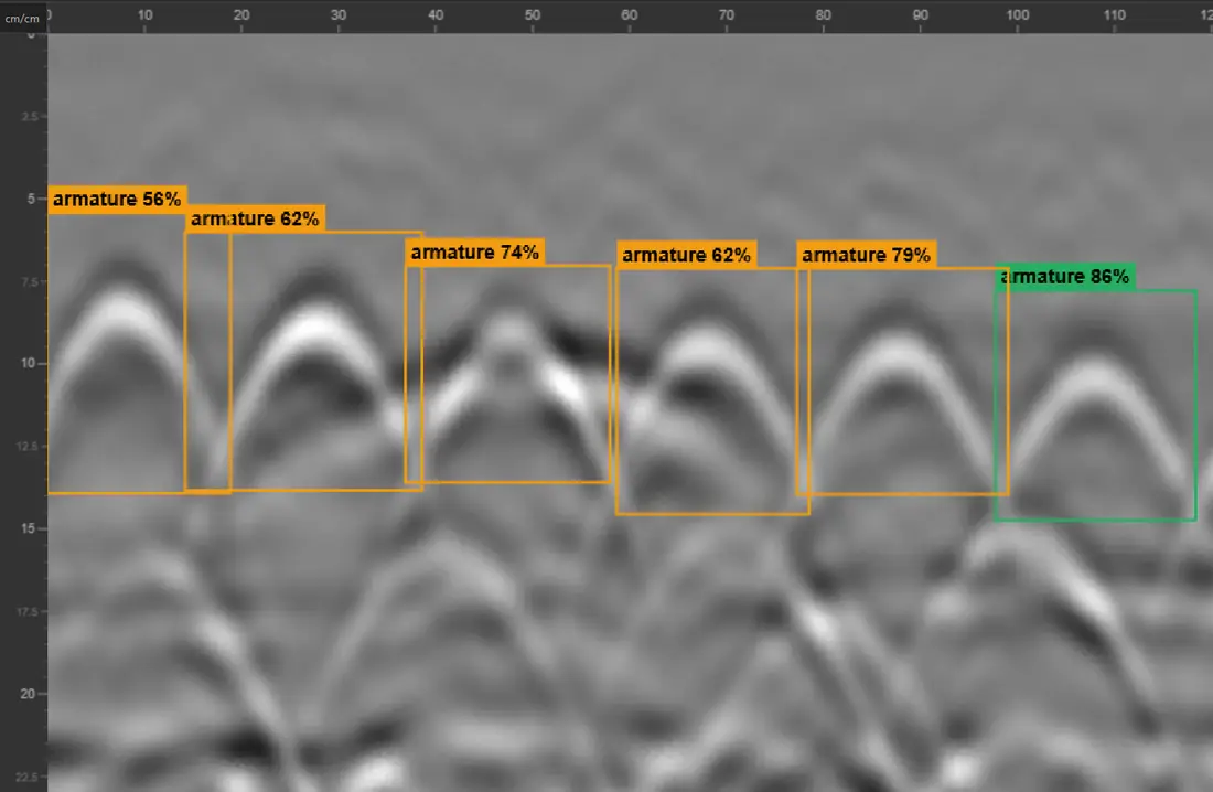
- Confronta con la descrizione del dataset: armature, sottoservizi, vuoti o interfacce vi sono indicati.
Calcestruzzo e strutture 20
- 3D Grid Concrete bloc wall with voids
- FLEX, NX25 and NX15 reference lines (MDSLab)
- Double layer of reinforcement and structural change (1 profile)
- Double mesh tightly embedded in a concrete slab with varying concrete cover
- FLEX 3D grid 60 x 60 cm (reinforced concrete beam and slab).
- Two layers of rebars in a reinforced concrete structure (3D grid)
- 3D concrete scanning over a slab-access ramp interface
- Voids in a concrete block wall
- Thickness detection above three masonry bridge arches
- Reinforced Concrete Slab with Expansion Joint
- 3D Grid on Reinforced Concrete — Welded Mesh Overlap for Rebar Picking
- 3D Grid on Densely Reinforced Concrete — Rebar Picking and C-Scan Tuning
- Beam-and-Block Floor — Cross-Polarisation on Inline and Cross-Line Channels
- Reinforced Concrete Column — Cross-Polarisation to Image the Far Face and Calibrate Permittivity
- Circular Reinforced Concrete Column : Perimeter Scan and Rebar Repositioning in Section View
- Reinforced Concrete Beam: Continuous Longitudinal GPR Survey with Markers at Two Columns
- T-Shaped Retaining Wall: Variable Thickness from a Vertical then Horizontal GPR Profile
- Reinforced Concrete Accessibility Ramp: Three Frequencies, Two 2.5 GHz Antennas and Cross-Polarisation on the Same Profile
- Formwork block Wall: 3D Grid Over a Void, 24 Crossing Profiles
- Pier shaft of a Toulouse Metro Line C viaduct with step-frequency GPR
Sottoservizi 7
- Detection of various buried utilities using a dual-frequency antenna (300 MHz and 800 MHz)
- Ground-penetrating radar detection of gas connections (HDPE polyethylene)
- Detection of buried pipes with the NX15 step-frequency ground-penetrating radar antenna
- Unrecorded Utility Crossing Under a Street — Parallel GPR Profiles at 350 MHz
- Georeferenced Multi-Utility Mapping - 30 RTK GPR Profiles at 300/800 MHz
- Multiple Utilities and Airwave — Distinguishing Surface Reflections from Buried Targets
- Buried utility crossing and two metal manhole covers — dual-frequency Compass NX profile (.nx)
Geotecnica e pavimentazioni 1
Patrimonio e archeologia 2
geotech,geosciences 2
geotech,routes 1
reseaux,geosciences 1
beton,reseaux 1
geotech,beton,reseaux 1
reseaux,beton 1
beton,geotech 1
Domande frequenti
Dove trovare dati georadar gratuiti?
Su GPRbase.com, che pubblica rilievi GSSI reali con il loro contesto. Si aprono gratuitamente in GPRviewer.
Posso usarli per formazione o pubblicazioni?
Sì, alle condizioni della licenza indicata nella scheda di ciascun dataset.
Quali formati?
Principalmente file GSSI .DZT, talvolta con file .DZX, tracce GPS o file Compass (.nx).
Vedi anche
Aprire un file DZT · Software georadar gratuito · Versione Pro · API IA armature
Apri GPRviewer gratuitamente